Laurel Mountain has a special place in my heart. I first glimpsed it from highway 395 at the end of an epic road trip in 2017 after finishing grad school. The colorful slopes caught my eye and I wanted to get a better view. I was delighted when I realized that a road went straight to it! It was stormy, I was alone, and I was blown away by the beauty and dramatic angle of the mountain. Little did I know that a classic climbing route went straight up the center!
Sherry and I visited the mountain again after completing a section of the Sierra high route this past August, which we had finished a day early due to incoming weather. We decided to play tourist since the snow (!) in Tuolumne foiled our climbing plans. I loved standing on the blustery shore of Convict Lake, getting pummeled by rain and taking photos. I showed Sherry the description of the route in Long and McNamara’s guidebook. We weren’t sure when, but we would be back!
October rolled around, and Sherry and I had plans to climb in Yosemite valley. But when the weather forecast looked more like July than October, we felt the pull of the high Sierra. We decided to go for Laurel, a relatively short outing for a short fall day. We made the drive out from the Oakland the night before and slept on a dirt road off highway 120. After a coffee stop at the Lee Vining Mobil, we arrived at Convict Lake around 8 am. We briefly debated bringing a rope for the climb but decided not to, which was definitely the right decision in retrospect. After some faffing about trying to find the bathrooms, which were closed, we made a pit stop at the fishing resort. A fisherman called us girls, which we chuckled about as we headed off on the trail. I’m nearly 40 years old, but I’ll take it.

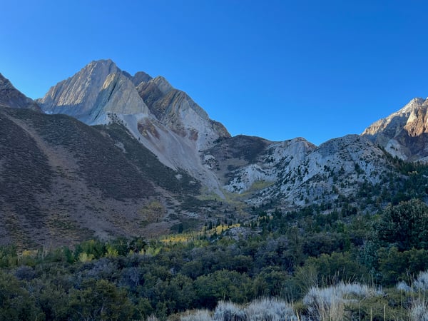
We passed several parties of hikers including a large group with dogs, but once the trail started up the mountain we were alone. We quickly made it to the base of the gully, a really cool feature that looks like it belongs in the desert southwest rather than the Sierra. I had read that the climb felt more like a canyoneering adventure, which was definitely apt. The first part of the climb consisted of a series of chimneys separated by lower angle steps and slabs. The bottom section was also the technical crux of the route, and I was glad that I brought climbing shoes. The rock up the very center of the gully was generally steeper than the surrounding rock. It was tempting to go off onto the side, but we soon realized that the rock quality was terrible even slightly off of the main gully.

We continued following the gully until we reached a wide open section of red rock. Here I was not sure whether to continue up to the right, following a striking band of smooth red rock, or to the left toward some grey slabs. The guidebook said something to the effect of “follow the red rock that sweeps across the face”. However, it also said to stay to the left after the first fork. I decided to follow the red rock, which was clearly the wrong decision. Fortunately I didn’t screw us over over too hard, but we had to do a big traverse back left, spending more time than was necessary on the terrible mid-mountain choss.

We finally made it back into the main gully and padded up some beautiful, smooth gray slabs that straddled the border of sun and shade. It was chilly, so I tried to stay in the sun as long as possible but finally had to give it up. As the slabs gave way to more chossy scrambling, we broke into the sun again. I heard another party below us who looked to be climbing quickly. The last several hundred feet to the summit was a slog over loose but less steep rock. Still, I was extra careful not to knock any rocks down. We later realized the other party had taken a different route to the summit anyway. Smart.

We spent some time at the summit snacking and soaking in the views. Red Slate Mountain looked particularly striking with its shoestring North Couloir covered in snow. The other party eventually arrived, and surprisingly it was two women! We said hi and took a summit photo for each other.
The descent ended up being the crux of the day. Our plan was to follow the northeast ridge to a less steep gully that would take us down the east side of the mountain. The guidebook warned not to drop too early, but we weren’t sure exactly which gully to aim for. We followed a really good trail until it cliffed out in some terrifying terrain. Definitely not that way. We stayed on the ridge and passed what I thought would be the correct gully based on the map, but that also looked steep and scary. Sherry noticed a line on her Gaia map that potentially indicated a trail much further down the ridge. We decided to aim for that, even though the path we had been following on the ridge was gone. Some krumholtz started to appear, and the way along the ridge got much slower going, with little sign of prior passage. Sherry was unsure, but I had faith in the line!

I finally made it to a patch of sandy ground and found, unmistakably, footprints! I joyfully shouted to Sherry that I had found the trail. It was surprisingly good despite being steep and sandy. We plunge-stepped down the sand and made it back to the main trail with plenty of daylight to spare. We finished the day on the lakeside trail, stopping to smell some Ponderosa Pine (they smell like vanilla if you put your nose right in the bark crack) and taking a frigid dip in the lake. After that we drove to the Rock Tub hot springs to relax for a bit before dinner. What a perfect day to spend on this unique mountain, with just enough excitement and almost no suffering. Now I can look up at Laurel and know what it’s like to be up there.